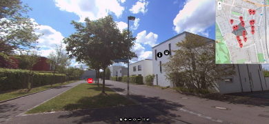
Residential area: Neues Bauen am Horn
| Screenshots der Anwendung | |
|---|---|
| Lage | |
Lade Karte … | |
| Lage / Geokoordinaten Startpunkt | Breitengrad: 50° 58' 42,6" N Längengrad: 11° 20' 30,12" O |
| Basisdaten | |
| Fachgebiet |
{{{Fachgebiet}}}
|
| Standort |
{{{Standort}}}
|
| Kategorie |
{{{Kategorie}}}
|
| Verfügbare Sprachen |
{{{Verfügbare Sprachen}}}
|
| Rundgangsdauer |
{{{Rundgangsdauer}}}
|
| Erstellungsjahr | {{{Erstellungsjahr }}} |
| Erstellt durch | {{{Erstellt durch}}} |
| Erstellungssoftware | {{{Erstellungssoftware}}} |
| Förderung | {{{Förderung}}} |
| Aufzeichnungsgerät | {{{Aufzeichnungsgerät}}} |
| Aufzeichnungsart | {{{Aufzeichnungsart}}} |
| Stereoskopische (3D) Aufzeichnung | {{{Stereoskopische (3D) Aufzeichnung}}} |
| Nutzung | {{{Nutzung}}} |
Description
The virtual tour through the residential area "Neues Bauen am Horn"" is based on a 360° model, and is embedded in a didactic scenario that can be adapted as desired.
Learning Objectives
The objective of the learning activity is to provide a rough draft of a drainage design for an existing area with approximately 60 residential buildings. The following drainage design principles are to be considered:
- Consideration of key planning principles.
- Drainage of domestic wastewater and stormwater in compliance with regulations
- Consideration of geographic and spatial structural conditions (including gradients, open spaces, underground parking)
- Optimal transfer points of the properties
- Coordination of pipe routing in public and private spaces
- Integration and connection to existing pipelines in the surrounding area
- Integration of rainwater management measures (including infiltration trenches, infiltration troughs, cisterns and roof greening)
Structure of the learning activity
The learning activity can be carried out completely virtually, i.e. all participants can be at different locations, provided there is an Internet connection sufficient for video conferencing systems. In terms of time, the learning activity fits into a double lecture (approx. 180 min). The structure can be adapted, the 360° model can be understood without an introduction.
- Introductory video lecture by Prof. Dr.-Ing. Jörg Londong on the basics of wastewater infrastructure planning and introduction to the specifics of the construction area (45 min). This can of course be replaced or supplemented by your own lecture.
- 360° model for conducting the virtual excursion [3]. The virtual excursion contains 10 points of interest (POI) and is conducted in groups of three learners each. For each POI, the 360° model contains information. With the help of a learning management system, a question has to be answered for each POI. Each group member takes one of three roles (model, questions, protocol) (60 min)
- Planning phase: In the excursion groups, the learners work out a basic drainage concept for the residential area they have walked through. They use a digital plan of the residential area for this purpose (45 min).
The performance can be evaluated on the basis of the questions (automatically), the protocol (manually) and the planning (manually). Evaluation guidelines are included in the accompanying material for the teachers.
Technische Voraussetzungen
Folgende technische Voraussetzungen sind für die 360°-Anwendung notwendig:
- Lernmanagementsystem (z.B. Moodle), in dem die Ressourcen zur Verfügung gestellt werden (Ablaufplan, Link zur Videovorlesung, Anleitung zur Bedienung des Rundgangs, Link zum Rundgang, Fragebogen, Protokollvorlage, Abgabe für Protokoll, digitaler Plan, Abgabe für Planung).
- Videokonferenzsystem
- Pro Teilnehmer ein Videokonferenzsystem-taugliches Endgerät (idealerweise Notebook, PC oder Tablet)
Bei Präsenzszenarien ändern sich die technischen Voraussetzungen. Eine Nutzung des 360°-Modells über eine VR-Brille ist möglich.
